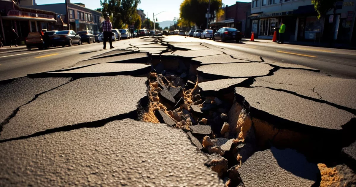

The New Madrid earthquakes of 1811-1812 resulted in one of the most significant natural disasters in the history of North America.
They occurred in the central Mississippi Valley, near the town of New Madrid in the Missouri Bootheel, but was felt as far away as New York City, Boston, Montreal, and the Gulf of Mexico. This series of earthquakes caused significant damage and forever shaped the landscape of the American Midwest.
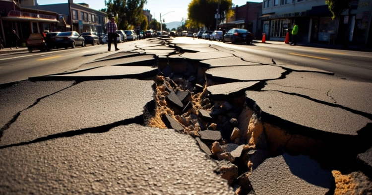
To understand earthquakes, it’s important first to understand the structure of the Earth. Our planet is made up of several layers: the inner core, the outer core, the mantle, and the crust. The crust and the uppermost part of the mantle form the lithosphere, which is broken into large sections called tectonic plates. These plates float on the partially molten part of the mantle called the asthenosphere.
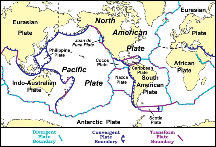
Earthquakes usually occur when these tectonic plates interact with one another. They may slide past one another, collide, or move apart. The boundaries where these plates meet are areas of high stress, as the plates are often locked together, resisting movement.
Over time, the stress at these plate boundaries increases as the Earth’s energy pushes the plates in different directions. When the stress exceeds the strength of the rocks at the boundary, the energy is released in the form of seismic waves. This sudden release of energy is what we experience as an earthquake.
The seismic waves produced during an earthquake propagate outwards from the epicenter – the point on the Earth’s surface directly above the earthquake’s origin or the hypocenter. There are two main types of seismic waves: body waves (which travel through the Earth’s interior) and surface waves (which travel along the Earth’s surface).
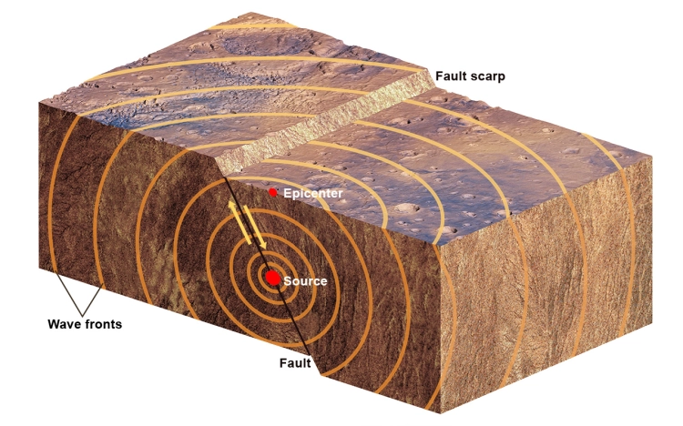
Body waves include P-waves (primary waves) and S-waves (secondary waves). P-waves are compressional waves that cause particles to move back and forth in the same direction as the wave, while S-waves are shear waves that cause particles to move perpendicularly to the wave’s direction.
Surface waves are slower than body waves and often cause the most damage during an earthquake. They include Love waves, which cause horizontal shearing of the ground, and Rayleigh waves, which induce an elliptical rolling motion, much like ocean waves.
The magnitude and intensity of an earthquake are measured using seismometers. The magnitude is a measure of the energy released during an earthquake, usually given on the Richter scale or the moment magnitude scale (Mw). The intensity, on the other hand, describes the effects of an earthquake at specific locations and is often recorded on the Modified Mercalli Intensity (MMI) scale.
To locate an earthquake, scientists use data from at least three seismograph stations. By calculating the difference in arrival times of the P and S waves, they can determine the distance of the earthquake from each station. When these distances are plotted on a map, the intersection of the circles drawn from each station with a radius equal to this distance marks the earthquake’s epicenter.
Despite advances in technology, predicting exactly when and where an earthquake will occur remains a challenge. While scientists can identify areas with a high probability of seismic activity based on historical records and plate tectonics, predicting the precise timing, location, and magnitude of an earthquake is still beyond current scientific capabilities.
Instead, researchers focus on seismic hazard assessment, which estimates the likelihood of an earthquake of a particular size occurring within a specific area and time frame. This information is essential for building codes, insurance rates, and emergency preparedness plans.
Understanding earthquakes is not just a scientific endeavor; it’s also crucial for societal resilience. Knowledge about seismic activity helps in developing better building designs and public safety protocols. Communities in seismically active areas often conduct drills and provide education about safe actions during an earthquake. These preparedness efforts can significantly mitigate the devastating impact of earthquakes on lives and property.
The main event of the New Madrid earthquake sequence began on December 16, 1811, in the early morning hours. An abrupt, powerful shaking awakened residents in the town of New Madrid, located in what is now Missouri.
This was not a singular, isolated event. Instead, it was the beginning of a seismic sequence that would include over a thousand aftershocks and several significant quakes in the following months. However, the earthquake on this date was the strongest and had the most profound impact.
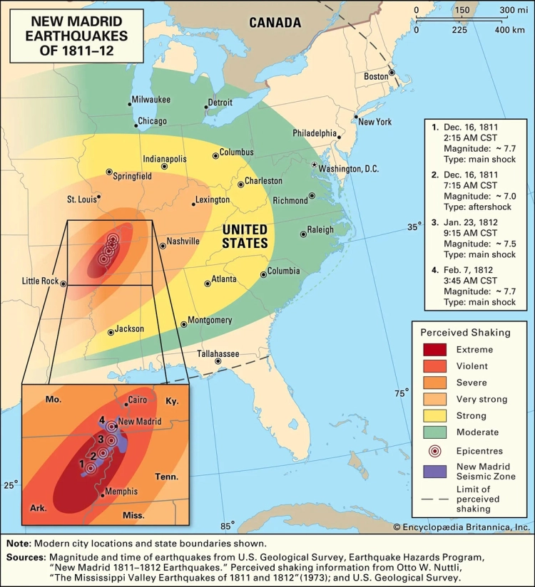
The New Madrid earthquake occurred around 2:15 a.m., with its epicenter in what is now, Southeast Missouri, not far from the town of New Madrid. The magnitude of this initial quake is estimated to have been between 7.5 and 7.9 on the Richter scale. This makes it one of the strongest earthquakes to occur in the contiguous United States.
The effects were immediately apparent. Buildings in New Madrid were severely damaged or completely destroyed. The ground rolled in visible waves, and large fissures opened, some spouting sand and water due to the process of liquefaction.
Although the immediate damage was concentrated in the Mississippi Valley region, the tremors from this earthquake were felt over an extraordinarily broad area. Reports suggest that shaking was felt as far away as New York City, Boston, Montreal, and the Gulf of Mexico. In areas closer to the epicenter, the shaking was so violent that it knocked people off their feet and caused structures to collapse.
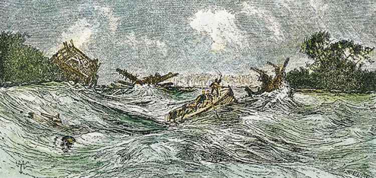
One particularly remarkable event that occurred during the quake was the temporary reversal of the flow of the Mississippi River. Landslides triggered by the New Madrid earthquake dumped large amounts of debris into the river, creating temporary dams. As the river’s water backed up behind these dams, it appeared to flow backward until enough pressure built up to break through the obstructions.
Witness accounts from the time describe a scene of terrifying chaos. People were thrown from their beds, and many fled from their homes in fear. Trees were seen to sway violently and crash into one another. Some eyewitnesses reported that the soil moved in fluid-like waves.
A notable account comes from the naturalist John James Audubon, who was in Kentucky at the time. He reported feeling the powerful shaking and described a loud noise resembling heavy thunder.
Despite the intensity and far-reaching effects of the quake, relatively few lives were lost. This was largely because the region was sparsely populated at that time. However, the New Madrid earthquake was a frightening experience for those who lived through it, and it had lasting impacts on the land and the people of the region.
After the initial quake, a series of aftershocks and several other significant quakes followed. Two major earthquakes occurred on January 23 and February 7, 1812. Each of these earthquakes had a magnitude estimated at approximately 7.0 to 7.5. The aftershocks continued for years – some sources suggest that they were felt intermittently through 1817.
The New Madrid earthquakes resulted in significant structural damage and changes to the geographical landscape. Sand blows caused by liquefaction were a common sight. This phenomenon occurs when the shaking of the ground causes water-saturated sand to flow to the surface, creating sand volcanoes. Additionally, the quakes resulted in the formation of temporary waterfalls on the Mississippi River, ground fissures, sinking of lands, and uplift of others.
Many buildings in the town of New Madrid were destroyed, and residents were terrified. Some accounts suggest that the shaking rang church bells in Boston. However, because the area was not densely populated, the earthquakes resulted in relatively few deaths.
The New Madrid Earthquakes left a lasting impact on the region, the evidence of which can still be seen today. The seismic events led to significant changes in the physical geography of the area. The violent shaking and the subsequent aftershocks resulted in landslides, ground fissures, and large areas of land subsidence.
One of the most remarkable events during the New Madrid earthquakes was the temporary reversal of the Mississippi River’s flow. This was due to landslides that pushed soil and other debris into the river, forming temporary dams. As the water accumulated behind these dams, it gave the illusion of the river flowing backward. When the dams finally broke, it resulted in the formation of several new lakes in the area, including Reelfoot Lake in Tennessee.
The movement of the ground also led to the creation of sand blows, or sand volcanoes, caused by the process of liquefaction. The intense shaking caused water-saturated sandy soil to liquefy and erupt to the surface, forming mounds of sand.
The quakes changed the course of the Mississippi River permanently, creating new bends and turns, as the ground beneath shifted and settled.
The New Madrid earthquakes also made a significant impact on our understanding of seismic activity. They demonstrated that powerful earthquakes could occur in the middle of tectonic plates and not just at their boundaries, which was a revolutionary concept at the time.
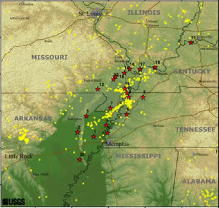
This awareness has led to increased monitoring and research in the New Madrid Seismic Zone. The U.S. Geological Survey and other agencies have installed seismometers and GPS stations throughout the region to monitor ground movement and detect seismic activity. This data helps seismologists better understand the behavior of intraplate earthquakes and aids in developing more accurate models for earthquake prediction and preparedness.
The knowledge gained from studying the New Madrid earthquakes has influenced building codes and emergency planning, especially in the central United States. Understanding the potential for significant seismic activity in this area has led to stronger, more earthquake-resistant construction practices and better disaster preparedness programs.
From a historical and cultural perspective, the New Madrid earthquakes have become part of the folklore and identity of the region. The event and its dramatic effects, like the temporary reversal of the Mississippi River, have been passed down in stories over generations.
The New Madrid earthquakes also had an impact on the native tribes living in the area at the time, influencing their movements and settlements. It’s believed that the quakes were a significant factor in the decision of the Chickasaw and Choctaw tribes to cede their lands in the affected region to the U.S. government.
The New Madrid earthquakes of 1811-1812 serve as a stark reminder of the immense power of natural forces. Despite occurring over two centuries ago, these seismic events still provide valuable lessons for us today.
One of the most profound lessons is the need to respect and appreciate the power of nature. The earthquakes altered the course of rivers, caused land to rise and fall, and even made the Mississippi River appear to flow backward. This dramatic reshaping of the landscape underscores how natural events can swiftly and permanently change our surroundings.
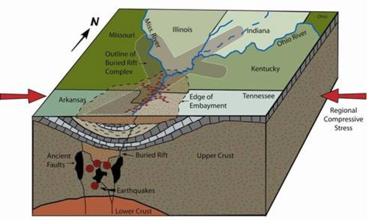
The New Madrid earthquakes were also a wake-up call about the risk of seismic activity in the central United States. Prior to these events, it was generally assumed that the risk of significant earthquakes was confined to areas along tectonic plate boundaries. The New Madrid earthquakes shattered this assumption, demonstrating that strong earthquakes could occur well within the interior of a tectonic plate.
In the aftermath of these events, scientists have dedicated much effort to understanding the seismicity of the New Madrid Seismic Zone and other similar areas. This research has provided essential insights into the nature of intraplate earthquakes, contributing to improved seismic risk assessments and better building codes and safety standards.
The New Madrid earthquakes taught us valuable lessons about the importance of disaster preparedness. Though these earthquakes resulted in relatively few fatalities, thanks to the sparse population of the region at the time, the level of destruction was immense.
This underscores the importance of preparing for natural disasters, especially in areas known to be at risk. Today, the lessons learned from the New Madrid earthquakes have been applied to the development of comprehensive disaster response plans. These plans include building codes that require structures to be able to withstand significant shaking, emergency response plans to ensure efficient aid delivery after an earthquake, and public education initiatives to ensure that individuals know what to do when an earthquake strikes.
Native American tribes have a long history of interpreting natural phenomena as signs or messages from the spiritual world. The New Madrid earthquakes were no exception. These seismic events were seen by many tribes as powerful omens. They were interpreted through the lens of their spiritual beliefs, often leading to significant decisions or changes in behavior.
The Chickasaw and Choctaw tribes, in particular, had settlements in the region affected by the New Madrid earthquakes. These seismic events caused significant disruption and fear, leading to a shift in tribal movements and settlements.
In fact, the earthquakes are believed to have played a role in these tribes’ decisions to cede their lands in the affected region to the United States government in subsequent years. The sense of instability and the physical changes to the land caused by the earthquakes likely contributed to their willingness to relocate to new territories.
The incorporation of events like the New Madrid earthquakes into the understanding of Native American history represents a significant evolution in the way we approach historical narratives. Rather than viewing these narratives solely from a political or sociological perspective, there’s increasing recognition of the importance of environmental and natural events in shaping history.
The New Madrid earthquakes, for instance, were not just geological phenomena. They had profound social and cultural implications, particularly for the Native American tribes who lived in the region at the time. Recognizing this fact has allowed historians and anthropologists to develop a more nuanced understanding of Native American cultures and their interactions with the broader American society during this period.
Finally, a growing recognition of the value of indigenous knowledge systems and perspectives has also contributed to an evolving understanding of Native American history. Traditional Native American interpretations of natural events like earthquakes offer valuable insights into the worldview of these cultures. They also serve as a reminder of the deep connections that indigenous cultures have with the natural world.